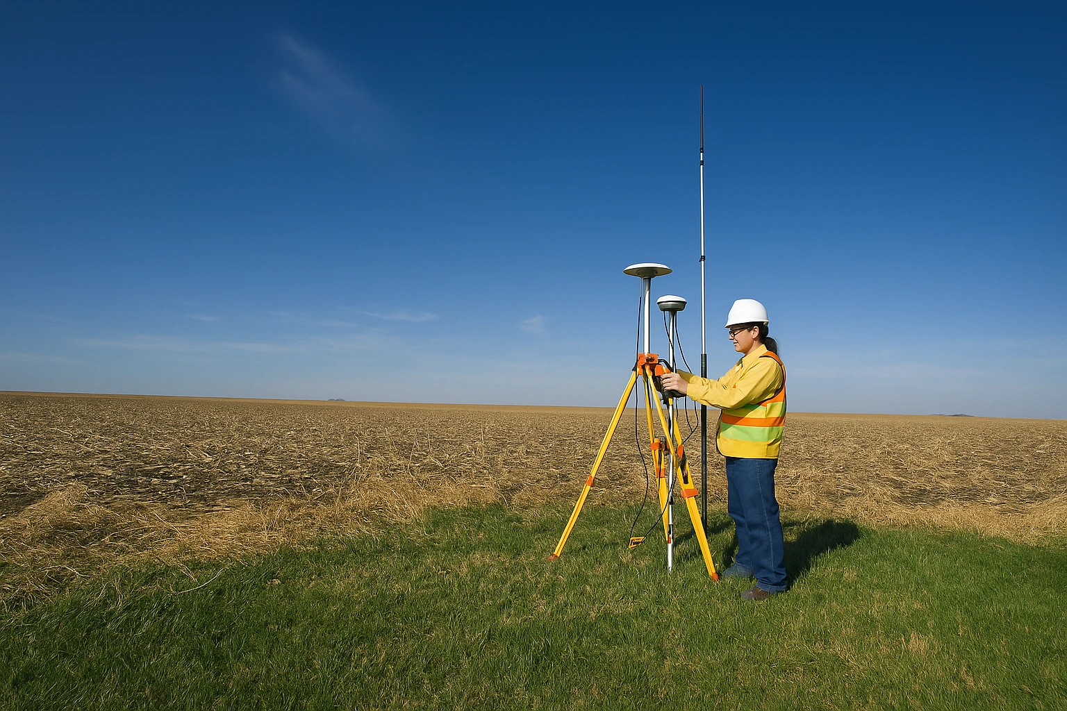
DGPS Field Survey for Accurate Land Mapping
Survey engineer capturing precise GPS coordinates on open land using RTK/DGPS equipment for high-accuracy mapping.

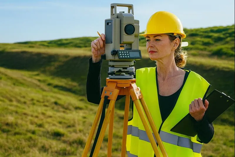
Total Station Survey in Progress
Land surveyor measuring distances and angles with a total station to support boundary marking and site planning.

Construction Site Levelling & Control
Auto level on tripod at a construction site to verify elevations, grades, and alignment for foundation and earthwork.

Precision Levelling for Building Projects
Engineer calibrating a levelling instrument on-site to maintain accurate height control and quality checks.

Optical Level for Earthwork Measurement
Close-up of a levelling instrument used to monitor cut-fill levels and ensure correct site development elevations.
Topographic Survey and Field Documentation
Survey professional operating a total station while recording observations for mapping and layout design.

Survey Team Working on Total Station Setup
Two-person crew conducting total station measurements for detailed site mapping and planning deliverables.

Aerial Land Parcel Mapping and Plot Demarcation
Drone-style aerial view showing plot boundaries and markers—ideal for cadastral mapping and land planning.
Our Vision & Mission
We are committed to delivering precise, technology-driven land surveying and planning solutions that empower confident decision-making and sustainable development.
Accuracy
We ensure high-precision survey results using advanced tools such as Total Station, DGPS, UAVs, and GIS technologies.
Technology
Leveraging modern surveying, mapping, and digital planning technologies to deliver reliable and future-ready solutions.
Integrity
We operate with transparency, ethical practices, and strict compliance to deliver trustworthy survey documentation.
Expert Team
Our experienced surveyors, engineers, and GIS professionals ensure seamless project execution from field to final deliverables.


Trusted Survey & Planning Partner Since 2013
Smart Survey & Planning is a professional land surveying, mapping, and geospatial solutions company serving government and private sectors. We specialize in DGPS surveys, drone mapping, cadastral surveys, infrastructure surveys, and detailed layout planning. Our focus is on delivering accurate data, smart insights, and reliable documentation for projects of all scales.
Our growth in numbers
With over a decade of experience, Smart Survey & Planning has successfully delivered high-accuracy land surveying, mapping, and planning solutions for government bodies, infrastructure developers, and private sector clients.
Government & Private Clients
Projects Successfully Delivered
Survey & Planning Services
Skilled Survey & GIS Professionals
Our Surveying & Geospatial Services
Smart Survey & Planning provides end-to-end land surveying, mapping, and planning solutions with high-accuracy outputs. Using DGPS, Total Station, UAV/Drone systems, GIS platforms, and digital mapping tools, we deliver reliable data, clear insights, and professional reports for government and private sector projects.
Trusted Surveying for Smart Development
Since 2013, Smart Survey & Planning has been helping clients make confident decisions with precise survey data and customized geospatial deliverables. From DGPS boundary demarcation and Total Station surveys to drone mapping, cadastral & revenue surveys, contour/level surveys, and GIS development—our team ensures accuracy, transparency, and on-time reporting for projects of every scale.
Explore Our Services
Total Station Survey
A high-precision ground survey used to measure angles, distances, and elevations for construction planning, land development, engineering layout, and topographic mapping. We deliver accurate site measurements with clear reporting and customized outputs.
DGPS Survey
Centimeter-level satellite-based positioning survey for boundaries, infrastructure, and government land records.
Contour & Level Survey
Mapping land slopes, elevation changes, and contours for drainage, roads, irrigation, and earthwork estimation.
Cadastral Survey
Precise measurement and legal mapping of land parcels for ownership verification and dispute prevention.
Drone Survey
UAV-based high-resolution aerial survey for fast mapping, 3D models, and elevation data.
Hydrographic Survey
Underwater survey measuring depths and features for irrigation, bridges, dredging, and flood studies.
GIS Mapping
Digital spatial data mapping and analysis for land use, utilities, assets, and planning.
Engineering & Infrastructure Survey
Precise survey services for roads, highways, canals, pipelines, bridges, and industrial projects.
Layout Planning
Optimized planning of plots, roads, utilities, and open spaces for compliant land development.
Asset Mapping
Digital mapping of utilities, roads, and physical assets for monitoring and management.
Construction Staking / Setting-Out
Accurate marking of foundations, columns, roads, and structures based on engineering drawings.
Renewable Energy Land Survey & Planning
Specialized land survey and planning consultancy for large-scale solar and wind energy projects.
As-Built Survey
Survey documenting actual constructed features for quality checks, billing, and facility management.
Volume & Earthwork Calculation
Precise cut-fill analysis and earthwork quantity calculation using drone and DGPS data.


What Our Clients Say
Trusted by government and private teams for accurate survey data, clear reporting, and on-time deliverables—powered by DGPS, Total Station, Drone Mapping, and GIS.
How We Work
A simple, accuracy-first process—from project understanding to field survey, GIS processing, and final report delivery with clear documentation.
Site Visit & Field Survey
Our team performs DGPS/Total Station/Drone survey as required, ensuring accurate points, levels, and boundary marking.
Data Processing & Mapping
We process field data, generate maps/contours/3D models, and prepare GIS layers and drawings (AutoCAD/GIS outputs).
Quality Check & Validation
We verify coordinates, elevations, and boundaries for accuracy, and match outputs to project and regulatory requirements.
Final Delivery & Support
You receive complete reports, maps, and digital files—plus support for revisions or client/government submissions if needed.
Our Team
Our experienced team combines strong field knowledge with modern technology to produce high-accuracy survey data, maps, and project-ready reports.
Meet Our Experts
Meet our expert team of surveyors, GIS specialists, and field engineers—delivering accurate data and reliable planning for every project.
Contact Us
Get in touch with Smart Survey & Planning for accurate, reliable, and professional land surveying and planning solutions.
Location
Mahavir Park Plot No. 94, Above Kambar Trading, National Highway 27 Service Road, Chandrapur, Wankaner, Morbi, Gujarat, India - 363621Branch-2: Om Decora 9 Square Wing-B Office 8th Floor, 150 Feet Ring Road, Nana Mava Circle, Rajkot, Gujarat 360003
info@smartsp.in
Call
+91 7016695788
Open Hours
Monday – Saturday: 9:00 AM – 6:00 PM
Get in Touch
Have a project in mind? Contact Smart Survey & Planning today to discuss your land surveying, mapping, and planning requirements. Our expert team is ready to assist you with accurate data and professional solutions.